 The Western Cross Timbers extend from far southern Oklahoma, including parts of Love and Carter counties, into central Texas, where it covers large parts of Montague, Young, Jack, Wise, Stephens, Palo Pinto, Parker, Eastland, Erath, Brown, San Saba, and Mills counties, as well as smaller parts of Clay, Cooke, Callahan, Hood, Coleman, and McCulloch counties. This area includes the towns of Weatherford and Mineral Wells; Stephenville lies on the eastern fringe, while Brownwood is on the western edge.
The part of this region north of I-20 is sometimes colloquially referred to as the Palo Pinto Mountains; the hills are isolated, rugged, and scenic, with spectacular bluffs along the Brazos River as it flows through the region. John Graves wrote about this area and its people in his classic book Goodbye to a River.
Coal mining has historically been an important activity, as bituminous coal deposits are found throughout the region. In the mid-to-late 19th century, Comanche Indians occupied this area, and it became a flash point for conflict between various groups of white settlers, the Comanche, and the U.S. Cavalry; Forts Belknap and Richardson were built in the area to protect this part of the frontier.
Richard Francaviglia has written an excellent introduction to the natural environment of the area called The Cast Iron Forest, so-named from a quote from Washington Irving who visited the area in the 1830’s and wrote that it was like traveling through “forests of cast iron.”
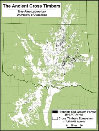
You can read more about the Cross Timbers and its vegetation at these sites: